Merrimack River Greenway Trail


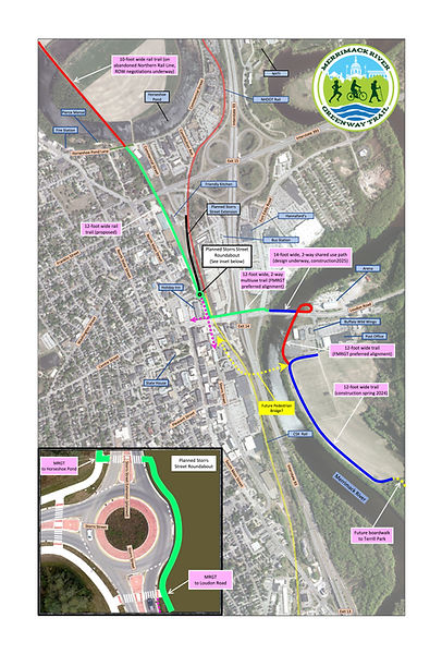
MRGT Overview: The Merrimack River Greenway Trail will extend from Boscawen to Pembroke. The northern section will follow the abandoned Northern New Hampshire Railroad right-of-way, while the southern section will feature a riverside greenway trail. It will be fully paved, measuring 12 feet wide in downtown areas and 10 feet wide in other locations.
Downtown Detail: This is one conceptual layout of the ultimate full buildout of the Merrimack River Greenway Trail.


GSRT Overview: The Granite State Rail Trail will stretch from Lebanon to Salem, providing off road recreation and non-motorized transportation opportunities for thousands of families living in proximity of abandoned railroad corridors. This is a very, very long range goal that will be achieved by a number of trail advocacy groups like ours.
Aerial view of the Merrimack River Greenway Trail and beyond, looking south to Salem.


First section of Merrimack River Greenway Trail
Completed fall 2020